Sunday, May 22, 2011

Coils and Springs

May 21, 2011
Not much happening on Friday, but Saturday we took a day trip to Alley Spring and Round Spring.  Alley Spring is the most photographed spring in the US.  It is spectacular with the blue green water and the red mill sitting on the edge of the spring.
Alley Spring and the Mill
Barney and grand daughter Porthos


A Muskrat in the spring
Betty and Wilma enjoying the spring


The spring is 32 feet deep, with an average daily flow of 81 million gallons. Barney, Fred, and Porthos hiked the short trail around the spring.  After pictures and of course getting our stamp in our passport books, we went on to Round Spring. Very pretty, but smaller and not as spectacular as Alley. There was no one at the ranger station, so alas, no stamp in our books for Round Spring.  Both springs are part of the Ozark National Scenic Riverways.

Fred and Barney got up close and personal with a couple of snakes found in the yard today.  See the pictures!
Missouri wildlife
Fred up close and personal


Barney "relocating" the snake
Barney capturing the monster


The rest of the day we just sat around and visited.
The chisel will pound out more on the rock pad later.

Thursday, May 19, 2011

Day Trip

Thursday, May 19, 2011

Wednesday wasn’t a blogging day.  We went into town for a few things, Fred mowed, and Barney poured some concrete.
Today was a lot more interesting!  We got an early start so we could make a day trip to St. Louis.  Fred wanted to go in for the release of the Ulysses S Grant presidential dollar.  Barney has wanted to stop in at St Louis Metallizing for a while, so this was a good opportunity.  We made arrangements to stop there around 10 am.  Larry took Barney and Fred on a tour of the shop while Betty and Wilma waited in Larry’s office.  Barney had dealt with Larry and this company while still in the work force.

After their tour, we decided to stop at the Arch and get our stamps there.  We had to wait around for about an hour to go up to the top of the Arch. That is a very interesting trip. You cram five people into the small cave like cars, and it takes four minutes to make the climb, and three minutes to go down.
It's pretty tall
The St Louis Gateway Arch


Betty and Barney enjoying the view
Wilma and Betty at the top
The Old Courthouse from the Arch
Barney & Betty, Wilma & Fred at the Courthouse


You can stay at the top as long as you want. It was not windy, so we didn’t feel it swaying, but you can feel the vibration of the cave cage cars on their trips up and down.  There was a Cardinals game in progress, and we could see the stadium from the top.  It looked like they had a good turnout.
We went over to the Old Courthouse and got a stamp there, then we were off for the Grant home.  We got there after the speeches, but in time to purchase some of the new dollar coins and get our books stamped.  We met up with Betty’s brother and SIL there and we all proceeded down the road.  Stopped and had some dinner, made a stop at Lowes, and then headed for the cave houses.  A great day!

Today’s stops makes 18 park locations where we have gotten stamps on this trip, plus six other stops.  We have been getting around!

Tuesday, May 17, 2011

What’s all this about stamps and stamp books?

May 17, 2011

Looking back at all of our blogs during the loooong trip to Missouri, we have talked a lot about getting stamps in our books. When we realized that most people won’t know what we are talking about, we thought we should probably explain what it really is, so here goes.

A few years ago, someone introduced us to the National Parks Passport Books which have information about all of the National Parks, National Monuments, National Historic Sites, National Rivers, and on and on and on. Well, our book looks like this:


Each National site we visit has one or more rubber stamps that go in the appropriate place in the book. There are sections for Pacific Northwest and Alaska, Western, Rocky Mountain, Southwest, etc. – all the way to the North Atlantic. In each section there are pages for the stamps as well as for extra stickers for the site we visit. We purchase the sets of stickers extra. The pages look like this when they are completed:
And the stamps look like this:


This year marks the 25th anniversary of the National Parks stamps program, so most stops include the anniversary stamp (like the one on the left above), and we have just begun our quest.
Study these carefully because there could be a quiz tomorrow!

Since we are parked and basically being lazy, there isn’t much else to report on.  More from the rolling cave houses of the Bedrock Bunch later.


Monday, May 16, 2011

Law and Order and Chaos of War

5/15/2011

 We were up about 7:00am and had breakfast in our cave-on-wheels in the Sallisaw/Fort Smith KOA in Sallisaw, Ok.  Breakfast consisted of vegi-omlet ala teridyctal with bronto-sauage and pancakes.   It’s tough to have to do the “hunter-gatherer” meals all of the time, but Betty and Wilma seem to be up for it most of the time.

Once again we headed east on I-40 to Fort Smith, AR.   We took in the Fort Smith National Historic Site.  The passport books were properly stamped and duly processed at the VC.    We didn’t realize that Fort Smith figured so prominently in the history of federal Indian policy.  We were all aware of Judge Isaac Parker’s Court, but didn’t totally understand the huge area that was under the court’s jurisdiction.  The court house and prison were very interesting and quite an eye opener. 
Fort Smith Courthouse
Barney and Fred in custody
Judge Parker's Courtroom


We headed north on I-540 and paused in Rogers, Ak, having discovered a random Taco Bell.  We dined on tacos and burritos then continued our trek northward.

We turned east on Rt. 62 to the Pea Ridge National Military Park.  It was a little difficult to locate on the map, however there are enough road signs that we got there without any problems. 

Pea Ridge is the site of a Union victory that helped to determine the status of the territory west of the Mississippi River.  Confederate hopes of occupying Missouri were dashed.  This year commemorates the 150th anniversary of the Civil War in the Ozarks.  The VC at Pea Ridge has an excellent video of the battle and there is a driving tour.  The displays in the VC are well done and very informative.  Naturally all of the passport books were stamped.
Barney and Betty at Pea Ridge

From Pea Ridge we headed for Springfield, Mo.   We were a little too late to stop at the Wilson’s Creek National Battlefield, so we continued east on Rt. 60.  After a fuel stop in Seymour, Mo, we continued on   to visit one of the Rubble branch of the Bedrock Bunch.  The rolling caves are currently parked but will probably be taking day trips for the next few weeks.

Look for more in the next week or so.

Saturday, May 14, 2011

Seeing Red (Feathers)

Saturday, May 14, 2011

The day began cool and clear. We didn’t need an early start because we were camped not too far from our next stop, the Washita National Battlefield.  We ate before leaving camp, and while Barney was repositioning his cave house, Wilma got to see a few cardinals for the first time in about 10 years. What a great start for the day.

When we arrived at the VC, we first talked to the ranger a little, and watched the orientation movie.  It was a nicely done movie, but sort of depressing seeing the re-enactment of the massacre of many Indians, including women and children.  We did learn more history that tied back into our second day of the trip, at the Golden Spike. After stamping our passport books, we took off across Oklahoma. 

Oklahoma doesn’t seem to think anyone driving through needs to use “the facilities.” Most of their roadside stops are picnic areas and say “no facilities.”  We did eventually see a “rest area” sign, but underneath was another sign “no facilities.” So don’t drink much along the way if you drive I40 through Oklahoma!   Fortunately we can stop and use our own!

This was more of a travel day, with our only other stop in Oklahoma City at the National Memorial there. This was not a passport stamp stop, we just wanted to see it since we were so close.
Oaklahoma City Murrah Building Memorial
Thoughts from the rescue workers


We wandered a little ways into the city and found ourselves trapped behind some traffic cones, so Betty hopped out, moved the cones and directed us through!  I think people watching got a good laugh out of that.  We then pulled over and filled Garmin in on where we wanted to go, and this time Garmin got it right.  We walked around the memorial grounds (very nicely done) and took a few pictures, then asked Garmin to get us back to the freeway. She tried to take us through an underpass with 11 feet 11 inch clearance, and since we “think” we are 11 feet 10 inches, we didn’t want to take a chance.  Looking around we could see a sign pointing us the right direction, so away we went.

Betty tried to get us to stop at a Taco Bell, but Wilma wasn’t paying any attention and we sailed right on by. And we never did see another one!

We later stopped to fuel up, and then went on to a KOA in Sallisaw for the night. There is a limit to how much off the grid we can take.  We are about 20 miles from Ft Smith, Arkansas, and will continue our quest for National Park passport stamps there tomorrow. 

From the rolling cave houses of the Bedrock Bunch, good night.

Sticks? and Stones

May 13, 2011

We left the rest area on the west side of Santa Rosa, NM about 7:30 am headed east on I40.  Last evening before we stopped, we had a 15 to 20 mph wind blowing on the back of the rolling cave houses. Beautiful tailwind!!  Today, Friday the 13th, that same wind was blowing at the left front fender.

We stopped at the Flying J in Tucumcari for fuel and breakfast.  It was a 2 swipe fill up because of the $75 limit on the pump.  Seems strange that we don’t encounter that $75 limit at the smaller stations – there must be some sort of message there.

We also tried to post the previous two blog entries since we had free wifi, but Blogger was down, still or again.

In Amarillo we took a little tour of the downtown area and the rail yard compliments of Barney and Betty (they were leading.)  We finally located Rte 136 (after asking directions) and headed north toward Fritch.  Mifi had a strong signal here, so got one post entered and another started before the next stop.

We turned left off 136 to Lake Meredith and the Alibates Flint Quarries VC at about 1:30 pm.  We were the only four people there. After the passport books were stamped, we watched a video about the Anasazi who lived there and worked the quarries. The ranger was very knowledgeable about the pueblo there and the trade that went on between the local “ancients” and the other cultures all around.  There were artifacts from the gulf, or Pacific, Plains people, even artifacts from as far away as Minnesota.  The local people traded flint blanks to the other cultures so they could make whatever tools they needed from the blanks.  A very interesting stop!!

We left the quarries and picked up Rte 152 in Borger to Pampa, where we refueled (no $75 limit) then Rte 60 to 33 to 283 toward Cheyenne, OK.  Somewhere in there we had a good mifi signal, so got yesterday’s blog posted.  We stopped at a campground in the Black Kettle National Grasslands.  It is a nice little park by a reservoir. It is off the grid. Tomorrow we will go on to Cheyenne.

It has been a beautiful, bright sunny day, except for the strong wind blowing on our nose all day.  But then it has been Friday the 13th all day.

More later from the Bedrock Bunch.

Friday, May 13, 2011

Secret City and Unexplained Staircase

May 12, 2011

Wow, sorry our posting was delayed.  Fairly early Thursday morning we left our really nice camping spot on Highway 4 and headed for Bandelier National Monument.  The drive through the mountains took us by a large caldera that was very pretty, and we passed a large herd of elk.  Wound around the mountain, and went down further into Bandelier.  The attendant at the park entrance told us where to park because we are slightly oversize with the rolling cave houses on, so we complied.  As soon as we were parked, a ranger came out of the VC and asked us to move to another area. Okay, we complied again. 

After stamping our passport books and watching the movie, we headed up the trail.  Bandelier has a very large circular unit that we enjoyed seeing. Without looking up the brochure, I’m thinking it had 90 some rooms. Here again there were park service employees working on the ruins. They were actually rebuilding some of the walls, and had photographs they were going by. There are also houses built up against the hill, and caves that were probably living spaces.  Barney took the trail up there and climbed some ladders to look inside. If you are into hiking, there are quite a few ruins along the canyon.
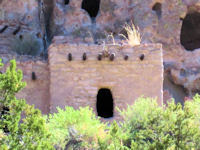
Fantastic architecture on the side of a hill
Barney at the "hillside homes"


We had our breakfast in the picnic area that was really nice, almost like a camping area with pull through spots and the picnic tables along a stream.  Fine dining at its best.
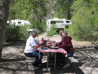
A beautiful spot for a picnic

Since we were so close, we decided to go to the museum at Los Alamos (the secret city). First we drove right up to an entrance into the national labs where we had to turn around or be searched, then we had to take a route through the hospital parking lot, up and down and around tight corners to get there because of some road work, but it was worth the effort. Some of the exhibits are hands on and the whole place was very interesting.

Next stop was Santa Fe. We found our way into old town with its very narrow streets, and lots of tourists, and discovered the public parking is not for rigs almost 12 feet high.  We did find a couple of spots near the visitor center, so got to see the Loretto Chapel and the miraculous staircase after all. We would have been disappointed to be so close and not see it. While still parked in Santa Fe, we tried to post the blog for yesterday, but Blogger was down.
The Miraculous Staircase

Next stop was the Pecos National Historical Park. It is a newer ruin, and has the remains of a church built around 1620.  Again, an interesting stop.

From there we took Route 3 down to I40.  3 was a narrow winding trail that after the house(okay, maybe there was more than one) in Villaneuva straightened out except for the ups and downs and eventually came to I40.  I guess the farm or two out there demands the road, otherwise there seemed to be no real purpose in it being there.

We went on to the next rest stop on I40, and stopped for the night.  If you look at a map and find Las Vegas, New Mexico, we were probably directly south of there on I40.  It is in the middle of nowhere and we could not get a mifi signal.  We still had not eaten, so fixed pizza in our rolling cave houses, then crashed.

Will get this posted when we can.

Aztec Ruins and Chaco Canyon

May  11, 2011

We left the Durango, Colorado KOA at 8:30 to 9:00 am, headed for Aztec, New Mexico and the Aztec Ruins National Monument.  We stopped at the welcome center in Aztec to get directions to the ruins.  A very nice young lady with a soft southern drawl helped us.  After getting brochures and directions, we asked where she was from.  She said “Tennessee.”  She said people ask her if she is from Texas and she tells them “NOooOO” with lots of emphasis.  She also recommended Olivers for breakfast.

The Aztec Ruins VC and self guided tour were very interesting.  There is a reconstructed “kiva” (ceremonial chamber) that is really amazing.  You have to marvel at the construction techniques and abilities of the ancients who built and occupied these dwellings.  We got our passport stamps and were off and running.
Barney, Betty and Wilma inside the Kiva
Those Ancients must have been short


We did eat breakfast at Olivers, and it was delicious.  We backtracked to Route 550 for the second time today, and headed south for “Chaco Canyon”.  If you have heard the expression”…20 miles of bad road,” and can mentally compress the 20 down to 13, you are beginning to have a vague idea what the 13 miles of dirt road into the National Historic Site is like.  Washboard like you have never seen!

Once into Chaco Canyon you are back on paved road.  The VC is in a temporary “yurt” while the permanent VC is being reconstructed.  The passport books were stamped and we went to check out the ruins.  Every place you stop you are amazed at the complexity and workmanship in these structures.  At one of the pueblos, Hungo Pavi, there were six or eight National Park Service workers repairing and repointing areas in the masonry.  The workers were all Native American who go from place to place in the Four Corners area, repairing ruins – not to rebuild, but to prevent or slow further deterioration.
Park Service Workers
Barney "shooting" the ruins


We again rose to the challenge of the 13 miles of dirt road and again headed south on 550. Next was a fuel stop at Cuba, New Mexico, then on to Route 4 toward our next destination.  We are stopped at a state campground, Vista Linda, on Route 4 for the night.  Since we are off grid, and absolutely no signal for phone or mifi in this canyon, this won’t get this posted until tomorrow.

After all the previous negative comments about the road into Chaco Canyon, it must not have been too bad because our gas light mantle survived intact.

Good night and sweet dreams from the Bedrock Bunch.

Tuesday, May 10, 2011

The Palace and The Pits

Tuesday, May 10, 2011

We really loafed around this morning, having breakfast while still at the Cortez KOA.  We pulled out shortly after 10am and backtracked into Cortez to fuel up.  Then we again headed for Mesa Verde National Park. 

Not fully understanding the markings on the park map, we stopped at one of the first turnoffs.  Fred, Wilma, and Barney all walked up the “short, gentle trail” according to the sign at the beginning of the path, and found that at 8500 ft elevation it was anything but gentle.  We huffed and puffed our way to the top and nearly froze doing it. It was still quite windy, and certainly not warm. Turns out the map markings only meant overlooks, not ruins. 

We continued on to the VC and stamped our Passport books.  We are having a good time with the books. Our next stop was at the museum. Since we already had our stamp for the park, we didn’t take our books in, and there at the stamp station was one we didn’t have. So Barney went back out and got the books.  There were actually two stamps there, but the ranger told us one was the same one we had gotten at the VC.

Behind the museum is the Spruce Tree House, a cliff dwelling. It is visible from the top, so Betty and Wilma found a bench and stayed there while Barney and Fred trekked down the hill to see it. The sign there said it was a strenuous walk and after the “gentle” walk earlier, Wilma wasn’t about to go down. It is a pretty large place with many rooms.  Amazing to think it is probably 800 years old.
Cliff Palace
Spruce Tree House


Barney going down into a Kiva
Barney in the Kiva


We then took the Mesa Top loop, and stopped, and stopped, and stopped!  There are many areas of different types of ruins.  Some on top of the mesa, and some cliff dwellings.  Most are visible from close to the parking areas, and some were just a short distance down a paved path.  One area is overlooking a fairly large canyon, and had a number of visible ruins, including the large Cliff Palace.  The wind had calmed, it was sunny and just warm enough, so we had a great day.

Betty discovered a stamp location in the Cortez area that we had missed.  We stopped at the rest area and called to see where exactly we needed to go to get that stamp.  Turns out it was at the museum in the park!  We did not go back!  Since we had talked to the ranger there about the stamps, seems like he would have told us if he had one for the other location. Oh well.

Grabbed a few snacks to munch on instead of fixing dinner, and headed to Durango.  Can’t park overnight at the Walmart there, so we are again in a KOA.

We will chisel out more on the rock pad later.

Ruins Viewing the Ruins

We spent the night in a nice little RV park in Monticello, Utah.

Betty and I were awakened by what sounded like a trashcan lid being blown around in the wind. The wind had blown all day and during the night we had wind, rain, thunder and some snow for good measure. Fred and Wilma, next door didn’t hear the noise. This morning we found one of our storage access panels was not locked. Once the panel was locked the “trashcan lid” was not heard from again.

Wilma fixed a great breakfast of biscuits, hash browns and sausage. With breakfast taken care of, we're off to explore the Four Corners Area. We took Rt. 191 south through Blanding then turned on Rt. 262 then took another left toward Hovenweep. This road has a few good spots in it but with the exception of a water filled pothole that covered the windshield with muddy water, we made it in good condition.

“Hovenweep" is Ute/Paiute for “deserted valley”. The VC (visitor’s center) is very nice and the staff is pleasant and accommodating. We got our passports stamped (first things first). Then set out to view the “Little Ruin Canyon”. The formerly occupied portion of the canyon is less than a mile long. The loop trail around the site is about one and one half miles long with a couple of fairly difficult spots. There are numerous ruins scattered along the rim of the canyon with more toward the canyon floor. Fred and Barney walked about halfway to the head of the canyon to a spot called Tower Point. The ruins are estimated to have been built in 1230 to 1275. The people who lived there farmed corn, beans, squash and possibly even cotton.
Fred and Barney
Barney, Betty & Wilma


In looking at the construction of these ruins you can’t help but admire the craftsmanship that the builders displayed using very simple tools. Those parts of the structures that are still standing display tight masonry seams; well mortared, smooth joints; smooth curved surfaces; and indications that some walls were plastered. It is apparent that the builders knew a good deal about construction using only available natural materials. I am really impressed! No trips to Home Depot for blocks and mortar mix.

From there we drove to the Anasazi Heritage Center in Dolores, Colorado. After getting our passports stamped we toured the museum and headed for Mesa Verde. According to the tour book the in-park campgrounds were supposed to open on May 7, however they won’t open until May 11 this year. We ate a late lunch inside the park and decided to check into an RV park and return to Mesa Verde tomorrow so we will have more time to enjoy it.

Monday, May 9, 2011

Smiting the Moabites

Sunday, May 8, 2011
Let the record books show…our visit to Arches National Park will be logged as a day of heat and gusty winds spent in a sea of humanity seeing the sights there to behold.
We started at the VC, stamped our books with three different stamps, and bought a sticker to go on the page.  Since the theater was not functioning, we did not view the spectacular movie to acquaint us with the park, so we headed out.  We stopped at most of the pull offs, and took several short walks to see the different formations and arches.

Barney, Betty & Wilma at Wolfe Ranch
Balanced Rock


Newspaper Rock
Delicate Arch


Stopped at the picnic area for our breakfast, but ate inside because of the excessive winds.  Then we finished our tour of the park. Wilma liked Canyonlands much better.
We stopped at the VC in Moab, picked up some brochures, and watched a blurry movie about what the whole area offers.  That kind of told us we didn’t really need to stop at the next thing we had planned (the Needles district of Canyonlands) because the sights involved some hiking in and Wilma’s knee isn’t doing much hiking right now.   We also stopped for a few groceries and fueled up in Moab.
Stopped down the road at a rest area for a short break, and Betty fixed our dinner that we ate at a windy picnic shelter.  We went on to see Newspaper Rock, then stopped at a small RV park in Monticello for the night.  After four days off grid, we are more than ready for a shower!  The inverter and mifi are working out pretty good to keep us off grid.  Glad to have them.
Monday am – we are also getting showers from the sky today to go along with extreme winds.  Our MPG will really take a dive.  We are planning on heading over to Hovenweep National Monument and stops in Canyons of the Ancients National Monument, then on to Mesa Verde National Park.
We will chisel out more on the rock pad later.

Sunday, May 8, 2011

Horse Thieves and Dead Horses

Saturday, May 07, 2011

After staying at a rest stop again, we drove through Horsethief campground for possibilities for tonight.  We really weren’t impressed, so decided to go on to Canyonlands National Park and see the sites.  We stopped at a picnic table at the VC and had our breakfast, then went inside and stamped our books. 
 
Originally had thought we could see most of Canyonlands and maybe some of Arches, but we barely got through the top section (Island In the Sky) of Canyonlands.  It is awesome.  Fred and Barney climbed about a jillion stairs to see Upheaval Dome.
Upheaval Dome

 Wilma’s highlight was seeing a few vehicles on the White Rim Trail, having read a few trip reports on the forum about it.
The White Rim Trail is down there!

  Fred said next time we come we can rent a jeep and do the trail ourselves. (not!) We stopped at numerous overlooks, and even though it isn’t very far to the next one, the view can be entirely different.  By afternoon it was quite windy, and we probably have as much windburn as sunburn.
 
We went into Deadhorse State Park and had dinner at a nicely located picnic table with more than a gentle breeze.  Got to share a little of our supper with a tiny greenish colored chipmunk.
 
Decided to find a camping spot before dark, so came out of town a ways to some BLM land.  Found a good site and are settled in for the night.  Here we are out in the sticks, and had a truck pull up and a couple came over to talk to us.  They also own a Bigfoot camper, and were surprised to find two of us together.  They didn’t have their camper with them and were heading for a motel, but checking out boondocking sites for the future.
Canyonlands Campsight
Twas a very good day, we are all tired, so more tomorrow from the chisel and rock pad of Fred and Wilma, and Barney and Betty.

Missiles and Whistles

May 6, 2011
Missiles and Whistles

We wanted to be at the Golden Spike National Historic Site early enough to see the 10:00 am locomotive moving into position.  We first stopped at the ATK (Thiokol) Rocket Park.  Lots of technical stuff I don’t understand since I’m NOT a rocket scientist, but very interesting, with a fairly large display of the missiles and rockets they manufacture. Barney is the rocket scientist and understood a lot more than the rest of us.  The 149 foot long reusable solid rocket motor was very impressive - not only the size, but the fact that the spent boosters parachute to the Atlantic Ocean. They are recovered from the water, and then sent to Florida where they are disassembled, returned to the ATK Thiokol plant in Utah, and refurbished for use on future space shuttle flights.
Booster rocket for space shuttle
The Rocket Park
With our normal penchant for being in on the action, we arrived at the Golden Spike just before 10, in time to hear them announce the usual schedule for the locomotives.  THEN they also announced that we just happened to be there on the day they were rehearsing for the May 10 anniversary celebration, so we got to see the whole re-enactment process of both the Central Pacific Jupiter and the Union Pacific 119 locomotives moving into position, with all the bells and whistles, and bells and whistles, and bells and whistles. If we had come on this trip any earlier in the year, we would have missed all of this because the trains don’t start running until May 1.
Fred & Wilma, Betty & Barney
And then they meet!


Five star and 11 on the 1 to 10 scale were some of our ratings for the Golden Spike visit.
Continuing on through massive construction on I15, we stopped at Timpanogos Cave in hopes of getting another stamp in our books. They don’t open until late May. You would think that since that is the case, the entrance station would have the stamp available (they do have the attendant to take your money to get into the attraction). Oh, well, that will be another trip.
Proceeded on down highway 6 through Price to Green River where we splurged and stopped at Subway for dinner.

After trying and failing to find a campsite in Moab, we back tracked to the rest stop at the highway. We’ll chisel out more on the rock pad tomorrow.